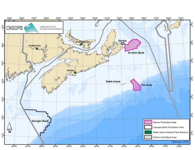
Marine refuges
Under the Fisheries Act, there are select management measures that help protect important species and their habitats, including unique and significant aggregations of corals and sponges. Termed, Marine Refuges, these measures are intended to be in place for the long-term, so they will make a lasting contribution to marine conservation. Within the offshore accord area the following areas have been identified as Marine Refuges:
Oil and gas activities within these areas will be assessed on a case-by-case basis as part of the Environmental Assessment and subsequent regulatory review processes.
Sable Island National Park Reserve
Sable Island National Park Reserve is located approximately 300 kilometers from Halifax, Nova Scotia. In 2013, the Government of Canada amended the Canada National Parks Act and the federal Accord Act to prohibit operators from drilling on or within 1 nautical mile (approximately 1.85 kilometers) of the Sable Island National Park Reserve.
Changes were also made to federal legislation regarding surface access rights to the Sable Island National Park Reserve, in order to limit oil and gas exploration activities. Surface access rights to the Sable Island National Park Reserve for oil and gas exploration activities are now limited to those activities with a low-impact on the environment, including seismic, aeromagnetic and aerogravity surveys, as well as geological or geophysical programs. It does not include the drilling of exploration wells.
A brief description of each permitted activity is provided below:
- A seismic survey is a technique used to obtain detailed images of the various types of rock layers located under the earth’s surface to determine the potential presence of oil and gas
- A eromagnetic and aerogravity surveys are completed by an airplane using the earth’s magnetic and gravitational forces to help understand the rock layers under the earth’s surface
- Geological programs involve the collection and analysis of the formation and composition of rocks, fossils or chemical changes in the composition of the earth’s surface materials
- Geophysical programs are defined as those involving the indirect measurement of physical features of rocks
Learn more about the Sable Island National Park Reserve here.
Georges Bank Prohibition Area
The Georges Bank Prohibition Area is located off the coast of southwest Nova Scotia, along the Canada-United States maritime boundary. In 1988, a moratorium was placed on all offshore oil and gas activities. This means that no exploration, drilling, or development of oil and gas can be completed by operators in the defined area. This includes the transportation of oil and gas produced in the area.
The moratorium was authorized by the Governments of Canada and Nova Scotia. Over time, the governments continued to extend the moratorium. In 2015, a joint ministerial notice issued by the federal Minister of Natural Resources and the provincial Minister of Energy and Mines, led to the creation of the Georges Bank Protection Act. This amended the Accord Acts to extend the moratorium until December 31, 2022, where governments will assess further requirements and restrictions.
This means that no oil and gas activity is currently permitted in the Georges Bank Prohibition Area.
Donkin Coal Block Area
The Donkin Coal Block Area is located off the coast of Cape Breton, Nova Scotia. In 2008, we issued an order prohibiting the issuance of licences, meaning no licences can be issued by us for offshore oil and gas rights in the defined area.
The order was issued to prevent competing resource development issues with any current or future coal mine projects. We made a fundamental decision to issue the order and the federal and provincial governments were provided up to 30 days to review the decision. Both governments approved our decision to issue the prohibition order.
As a result of the prohibition order, the Government of Canada created the Donkin Coal Block Development Opportunity Act and the Government of Nova Scotia updated the Undersea Coal Mines Regulation Act that amends the provincial Accord Act.
This means that no offshore oil and gas activity is currently permitted in the Donkin Coal Block Area.
Species at Risk Act Critical Habitat
Critical habitat is defined in Species at Risk Act as the habitat that is necessary for the survival or recovery of a listed wildlife species and that is identified as such in the recovery strategy or action plan for the species. Section 58 of Species at Risk Act prohibits the destruction of any part of the identified critical habitat.
There are several areas offshore Nova Scotia that are identified and protected critical habitat for aquatic species at risk. These include Zone 1 of the Gully Marine Protected Area, Shortland and Haldimand Canyons for the Northern Bottlenose Whale, Scotian Shelf population, and Roseway and Grand Manan Basins for the North Atlantic Right Whale.
Any oil and gas activity that has the potential to affect an aquatic species at risk in a way that is prohibited by Species at Risk Act will require a review by Fisheries and Oceans Canada. To see the distribution of aquatic species at risk and locations of their critical habitat in the Maritimes region please visit the Fisheries and Oceans Canada website aquatic species at risk mapping tool here.