Public Registry: EAs

When an operator applies for an activity authorization, we build on the information collected during a Strategic Environmental Assessment and other relevant previous environmental assessments, and require the operator to create a project-specific Environmental Assessment to help us determine how the proposed activities may affect ocean life. Search our collection of documents related to Environmental Assessments that are in progress or have previously been conducted in the Canada-Nova Scotia offshore area.


For more information or to obtain copies of any of the documents listed, including current or archived Environmental Assessments and Strategic Environmental Assessments, please contact us at info@cnsopb.ns.ca.

Our Public Registry: Environmental Assessments contains documentation related to all Environmental Assessments in progress or previously conducted in the Canada-Nova Scotia offshore area. An Environmental Assessment must be completed to support an activity authorization application that may be submitted to us by an operator. Environmental Assessments are required:

  • For projects that don’t trigger the federal Impact Assessment Act (referred to as non-designated projects)
     
  • As part of an Impact Assessment conducted by the Impact Assessment Agency of Canada (formerly the Canadian Environmental Assessment Agency) for projects that trigger the federal Impact Assessment Act (referred to as designated projects)

Environmental Assessments are developed as part of the environmental review to help us, operators, Indigenous communities, stakeholders and the public learn more about environmental considerations for a specific offshore area where an operator is applying for an activity authorization. We use environmental assessments to make informed decisions, and identify any restrictive or mitigative measures the operator should use to minimize or reduce potential oil and gas effects on the environment while conducting their activity.

You can access the following types of documents in our public registry:

•    Scoping documents (draft and final versions)

•    Environmental Assessment (draft and final versions)

•    Comments received on any draft documents

To search our public registry, click on the name of the Environmental Assessment program below.

Multiklient Invest’s Multi-Year Seismic Program

Operator: Multiklient Invest | Activity Status: On Hold  | Federal EA Applies: No

The Environmental Assessment has not been submitted. The Project Description and/or Scoping Document provide the following information for Multiklient Invest’s potential multi-year seismic program for an undefined period between 2020 and 2028. Specific data acquisition plans for 2D and 3D surveys are not yet determined and will depend on industry demand.

 * Area shaded in green represents the Environmental Assessment area.

Location:

The proposed project area covers much of the offshore deep water and slope from the Laurentian Channel to the east, to the Canada-United States jurisdictional border to the west. The proposed project area also includes many of the shelf banks, from Misaine Bank in the east, to LaHave Bank in the west. Bacarro, Browns and Georges Banks are excluded.

Special areas within the proposed project area include Sable Island National Park Reserve, Shortland and Haldimand Canyon, the Western/Emerald Banks Conservation Area (fisheries restrictions), and Corsair and Georges Canyons Conservation Area (fisheries restrictions). The Gully Marine Protected Area and the St. Anns Bank Marine protected Area are excluded.

Ecosystem:

There are several fish, marine mammal, sea turtle and bird species with special conservation status known to occur within the proposed project area, including the endangered blue whale, North Atlantic right whale, Northern bottlenose whale, leatherback turtle, wolffish species, piping plover, and the roseate tern, among others.

Commercial and Recreational Uses:

Fishing using all marine fishing gear types used in Nova Scotia occurs throughout the proposed project area. 

Other ocean uses in and around the area include scientific research, military activity and offshore oil and gas exploration activity. Activity and infrastructure associated with the Sable Offshore Energy Project and the Deep Panuke Offshore Gas Development Project currently exist (decommissioning is underway for both) on the Sable Island Bank, and to the south is the BP Canada Energy Group ULC owned Exploration Licence 2434R.

* All links below are Adobe Acrobat.

Date Document Title Author
03/12/2018 PDF icon Final Scoping Document CNSOPB
03/12/2018 PDF icon CNSOPB Public Comments Report CNSOPB
02/11/2018 PDF icon Comments on Scoping Document Fisheries and Oceans Canada
29/10/2018 PDF icon Comments on Scoping Document Environment and Climate Change Canada
29/10/2018 PDF icon Comments on Scoping Document Wolastoqey Nation in New Brunswick
29/10/2018 PDF icon Comments on Scoping Document Patrick Lyne
29/10/2018 PDF icon Comments on Scoping Document Migmawel Tplutaqnn
29/10/2018 PDF icon Comments on Scoping Document Hon. Wilfred P. Moore
25/10/2018 PDF icon Comments on Scoping Document Kwilmu’kw Maw-klusuaqn Negotiation Office
24/10/2018 PDF icon Comments on Scoping Document Maritime Aboriginal People Council
29/09/2018 PDF icon Scoping Document CNSOPB
26/09/2018 PDF icon Project Description Multiklient Invest

Statoil (now Equinor) Waverley Seismic Program

Operator: Equinor (formerly Statoil Canada Limited). | Activity Status: On Hold | Federal EA Applies: No

The Environmental Assessment has not been submitted. The Environmental Assessment preparation is currently on hold. Specific data acquisition was originally planned to occur in 2018. A 3D survey and accompanying geohazard surveys were proposed. The Project Description and/or Scoping Document provide the following information for Statoil’s potential Waverley seismic program:

* Area shaded in green represents the Environmental Assessment area.

Location:

A program may occur in future years, within and adjacent to Exploration Licences 2435 and 2436, which are located approximately 350 kilometres southwest of Halifax.

There are no designated special areas within the proposed project area; it is adjacent to George’s Bank. 

Ecosystem:

The area is within proposed critical habitat for the leatherback turtle. This critical habitat area has not yet been established.

The majority of whale and migratory bird species that occur offshore Nova Scotia are likely to transit through the area when migrating in the spring and fall, including species at risk, such as the North Atlantic right whale. Fish species at risk, such as the wollffish, may be present in the area. Migratory birds pass through the area in spring and fall.

Commercial and Recreational Uses:

Fishing gear types that may be used in the area are mostly long-line pelagic gear given the water depth, such as tuna and swordfish, and some groundfish and invertebrate fisheries as well.

Other ocean uses that may occur in and around the area include scientific research and military activity.

* All links below are Adobe Acrobat.

Date Document Title Author
01/09/2017 PDF icon Scoping Document for the Environmental Assessment CNSOPB
19/07/2017 PDF icon Project Description Statoil Canada Ltd.

Scotian Basin Exploration Drilling Project

Operator: BP Canada Energy Group ULC | Activity Status:  Completed | Federal EA Applies: Yes

The Scotian Basin Exploration Drilling Project Environmental Assessment report provides a summary and the main findings of a federal Environmental Assessment conducted by the Canadian Environmental Assessment Agency (now the Impact Assessment Agency) based on the requirements of the Canadian Environmental Assessment Act, 2012.

The Environmental Assessment covers up to 7 exploration wells, drilled in the period from 2018 to 2022. In 2018, BP Canada Energy Group ULC drilled one well. Additional wells may be drilled.

The full compliment of activities assessed in the EA includes:

  1.  Seabed inspection
     
  2.  Drilling
     
  3. Vertical seismic profiling
     
  4.  Well flow testing
     
  5.  Abandonment of the well(s)
     
  6. Supply and servicing of the project.
* Area shaded in green represents the Environmental Assessment area.

Location:

In the environmental assessment, BP Canada Energy Group ULC proposed to drill up to 7 wells within its offshore exploration licences. At the time of publication of the environment
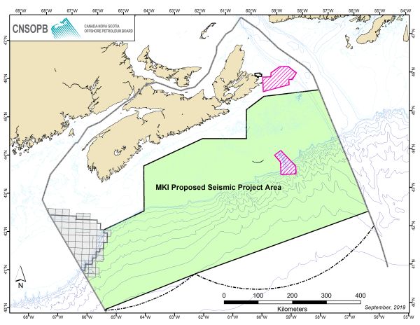
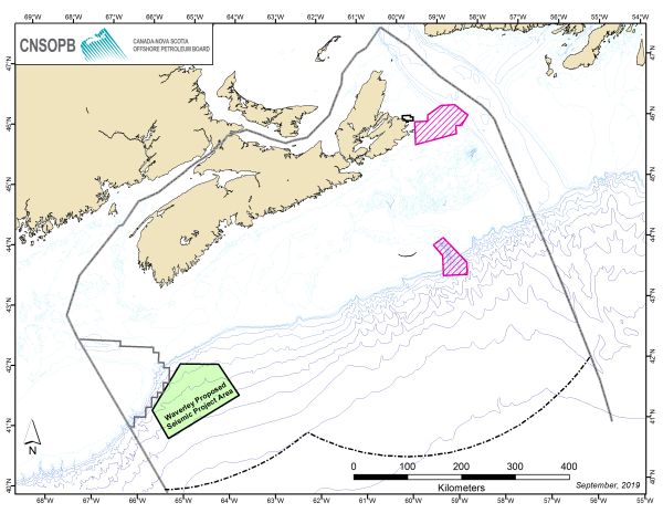
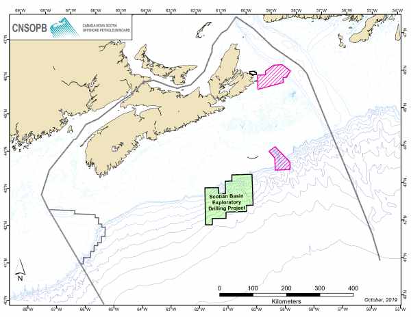
al assessment, BP Canada Energy ULC held Exploration Licences 2431, 2432, 2433 and 2434, which were located between 230-370 kilometres southeast of Halifax and 48 kilometres south-southeast of Sable Island National Park Reserve. BP currently holds Exploration Licence 2434R, which covers the following geographic area (which is a combination of amalgamation and reduction of the original exploration licence areas)

There are no designated special areas within the proposed project area; it is adjacent to the Western/Emerald Bank Conservation Area (fisheries restrictions).

Ecosystem:

The majority of whale and migratory bird species that transit the shelf-slope break in the Canada-Nova Scotia offshore area and are likely to travel through the area when migrating in the spring and fall. This includes migratory birds and species at risk, such as the North Atlantic right whale, leatherback turtle and wolffish. Several canyons are present in the environmental assessment area, including those visited by beaked whales, such as the northern bottlenose whale.

Commercial and Recreational Uses:

Fishing using multiple gear types occurs in the area, including invertebrate fisheries such as lobster, shrimp, scallop and crabs. There are also groundfish fisheries, and long-line pelagic fisheries present in the area.

The possible effects on potential or established Aboriginal or treaty rights are also considered in the environmental assessment. Fishing by First Nations communities for commercial or traditional purposes is the primary rights-based activity that could have been affected by the activity.

Environmental Assessment Conclusions

The environmental assessment concluded that the recommended measures to mitigate potential environmental effects on fish and fish habitat and on commercial fisheries, and to prevent or reduce the effects of accidents and malfunctions, are appropriate measures to accommodate for potential impacts on rights.

The environmental assessment concluded that the project is not likely to cause significant adverse environmental effects, taking into account the implementation of mitigation measures. This conclusion covers the following potential effects:

1.   Effects on fish habitat caused by the discharge of drilling waste (used drilling fluid and cuttings) to the marine environment

2.   Effects on marine mammals and sea turtles caused by underwater noise from vertical seismic profiling operations and from mobile offshore drilling unit operations

3.   Effects on migratory birds caused by lights on the mobile offshore drilling unit and platform supply vessels and, if well testing is required, flaring

4.   Interference with commercial fisheries, Indigenous or otherwise, including effects on fishing activity that may be caused by the need to avoid the 500 metre safety (exclusion) zone around drilling operations.

* All links below are Adobe Acrobat.

Date Document Title Author
01/02/2018 PDF icon Environmental Assessment Report Canadian Environmental Assessment Agency
01/02/2018 PDF icon Environmental Assessment Decision Statement Canadian Environmental Assessment Agency
22/11/2017 PDF icon Draft Environmental Assessment Report for Public Comment Canadian Environmental Assessment Agency
16/09/2015 PDF icon Draft Environmental Impact Statement Guidelines Canadian Environmental Assessment Agency
19/08/2015 PDF icon Scotian Basin Exploration Drilling Project – Project Description Summary Document BP Energy Group ULC
19/08/2015 PDF icon Scotian Basin Exploration Drilling Project – Project Description BP Energy Group ULC

Public Registry Archives: Environmental Assessments

Environmental Assessments Archives

The following Environmental Assessment projects have been archived, for information pretaining to these projects please email info@cnsopb.ns.ca.

Date

Project Title

Operator

02/12/13

Shelburne Basin Venture Exploration Drilling Project

Shell Canada Limited

15/07/13

BP Exploration (Canada) Tangier 3D Seismic Survey

BP Exploration (Canada) Limited

29/06/12

Shelburne 3D Seismic Survey for Exploration License 2423,2424,2425, & 2426

Shell Canada Limited

28/08/06

Deep Panuke Offshore Gas Development Project

Encana Corporation

19/07/11

Scotia Exploration South Triumph 3D Seismic Survey for Exploration License 2419

Scotia Exploration

02/02/10

ExxonMobil Seabed Survey - Potential Sable Subsea Satellites Development

ExxonMobil

10/08/09

Husky Energy 2009-2018 Seismic Survey Program for the Sydney Basin Offshore Area

Husky Energy

31/01/06

Exploration Drilling Activities on Marauder (Exploration License 2415) and Marconi (Exploration License 2416) Blocks

Canadian Superior

26/01/06

Seismic Exploration Activities on Marauder (Exploration License 2415),Marconi (Exploration License 2416) & Mariner (Exploration License 2409) Blocks

Canadian Superior

03/10/05

EnCana Shallow Water Exploration Program

EnCana

03/10/05

2005-07 Vertical Seismic Profiles (Exploration License’s 2360, 2387, 2389, 2357 and Production Licence 2901)

EnCana

17/12/04

3D Seismic Survey Laurentian Channel

ConocoPhillips

29/07/04

Wellsite Survey at Huckleberry (Exploration License 2389)

EnCana

30/06/04

Proposed Wellsite Surveys Exploration License 2409 (Mariner Block)

Canadian Superior

07/06/04

3D Seismic Survey Exploration License 2359 (Mahone)

Chevron Canada

13/05/04

Vertical Seismic Profile at Cree (Exploration License 2361)

ExxonMobil

30/04/04

Exploration Drilling on Exploration License 2407

BEPCo. Canada Company

19/04/04

2D Seismic Survey Laurentian Subbasin

ConocoPhillips

15/03/04

2D/3D Seismic Survey Exploration License 2389 (Blueberry)

EnCana GSI

15/03/04

3D Seismic Survey Exploration License 2408 (Hawkesbury)

EnCana

30/12/03

2D Survey Program Orpheus Basin

GSI

24/11/03

Vertical Seismic Profile at Mariner I-85 (Exploration License 2409)

El Paso

20/11/03

Phase II Decommissioning Program Cohasset/Panuke (Production Licence 2901 & Production Licence 2902)

EnCana

03/11/03

Vertical Seismic Profile at Weymouth A-45 (Exploration License 2380)

EnCana

29/11/03

3D Seismic Survey Exploration License 2403 (Cabot)

Anadarko Canada Corp

24/09/03

Vertical Seismic Profile at MarCoh D-41 (Production Licence 2901)

EnCana

21/08/03

3D Seismic Survey Exploration License 2357 (Grand Pre)

EnCana

06/08/02

Hunt Oil 2D Seismic Survey in Sydney Bight

Hunt Oil Company of Canada