Public Registry: SEAs

Conducting a Strategic Environmental Assessment is important. It helps us highlight environmental sensitivities. It’s also important that the public can access Strategic Environmental Assessment documents to understand the sensitivities and learn more about environmental protections that should be taken into account for the area covered by the assessment. Search our collection of Strategic Environmental Assessments conducted in the Canada-Nova Scotia offshore area.

For more information or to obtain copies of any of the documents listed, including current or archived Environmental Assessments and Strategic Environmental Assessments, please contact us at info@cnsopb.ns.ca or 902-422-5588.

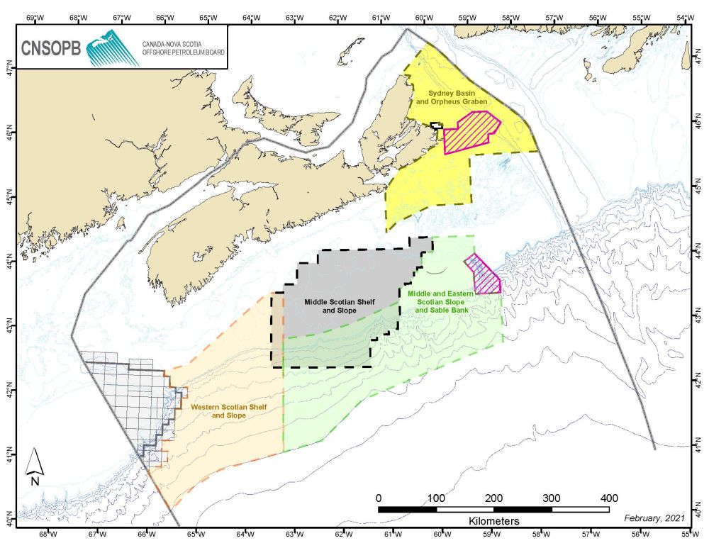
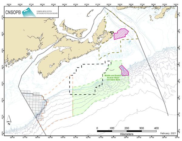
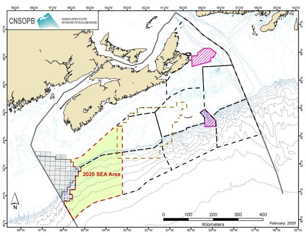
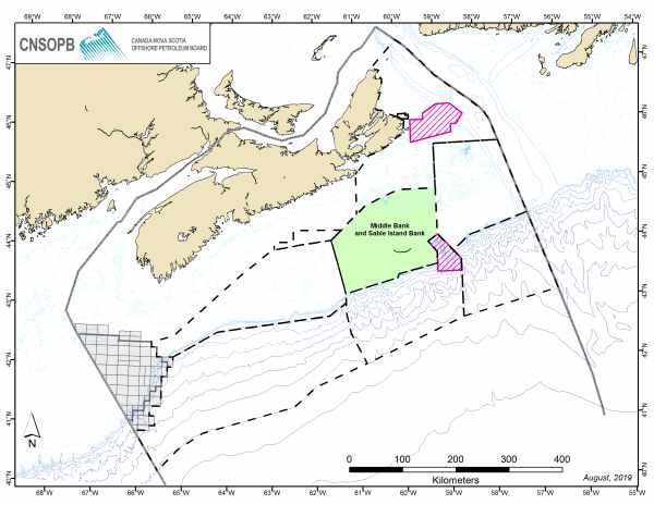
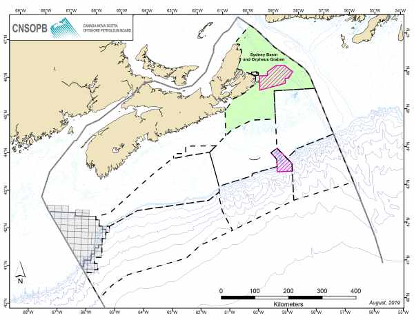
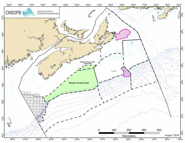
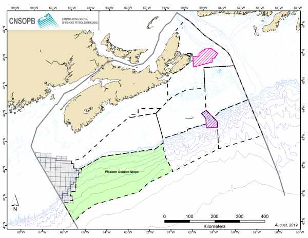
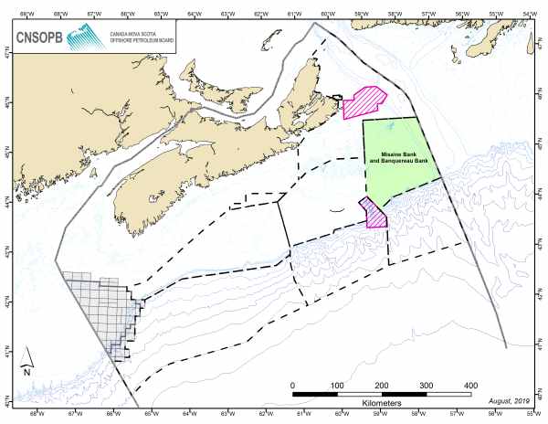
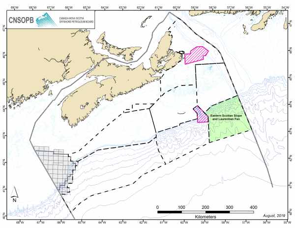
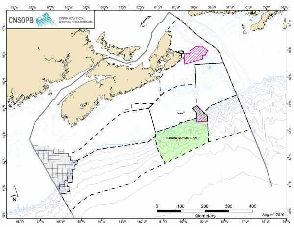
Our Public Registry: Strategic Environmental Assessments is a collection of documents we maintain that are related to a specific Strategic Environmental Assessment Study area. These documents are developed to help us, operators, Indigenous groups, stakeholders and the public learn more about environmental considerations for a specific offshore area, such as lands potentially under consideration for a Call for Bids area. We use Strategic Environmental Assessment to make informed decisions and identify environmental sensitivities and any general restrictive or mitigative measures we should consider to protect the environment prior to our review of a project-specific environmental assessment completed by an operator during the activity authorization process.

You can access the following types of document in our public registry:

  • Scoping documents (draft and final versions)
     
  • Strategic Environmental Assessment (draft and final versions)
     
  • Comments received on any draft documents

To search our public registry, click on the name of the Strategic Environmental Assessment study area below.

Middle and Eastern Scotian Slope and Sable Island Bank Areas

*Area shaded in green represents the Strategic Environmental Assessment project area.

Location:

The SEA study area extends from the Gully Marine Protected Area (MPA) in the east to the deep slope waters of the Middle and Eastern Scotian Slope in the southwest. 
Special Areas within the study area include Sable Island National Park Reserve, the Gully MPA, and the Western/Emerald Banks Conservation Area Marine Refuge. Sable Island is also protected as a Migratory Bird Sanctuary and an Important Bird Area (IBA).

Ecosystem:

There are fish, marine mammals, sea turtles, and bird species with special conservation status known to occur in the study area (e.g. the Northern bottlenose whale, blue whale, white shark, leatherback sea turtle and roseate tern, as well as other listed species). The SEA area includes critical habitat for the endangered Northern bottlenose whale. The SEA area also includes habitat forming benthic species, such as deep sea corals.

Commercial and Recreational Uses:

Other ocean uses in and around the study area include commercial fishing, shipping, tourism, scientific research, and military activity.

The main fish species currently targeted by commercial fisheries include, but is not limited to, commercially important invertebrate species such as shrimp, clam, snow crab, sea scallop, red crab and rock crab, as well as finfish such as Atlantic herring, bluefin tuna, Atlantic cod, Greenland halibut, haddock, mackerel, pollock, redfish and swordfish and other species. Lobster is currently unlikely to be targeted within the Study Area, though it may be in the future. Some harvesting of gray and harp seals may also occur in the area.

Indigenous Uses:

Indigenous fisheries in the study area may include the targeted commercial fisheries species listed above, with special emphasis on lobster, halibut and flounder.
Migratory species (including fish, birds and mammals) that move through the study area could potentially be harvested by Indigenous communities in coastal areas through commercial fishing, food, social and ceremonial (FSC) fishing, commercial communal fishing or through other harvesting activities.

Date Document Title Author
26/05/2022 PDF icon Middle and Eastern Scotian Slope and Sable Island Bank Areas Strategic Environmental Assessment Final Report CNSOPB
22/12/2021 PDF icon Comments on Draft Strategic Environmental Assessment Offshore Alliance
17/12/2021 PDF icon Comments on Draft Strategic Environmental Assessment World Wildlife Fund
17/12/2021 PDF icon Comments on Draft Strategic Environmental Assessment Canadian Parks and Wilderness Society - Nova Scotia Chapter
16/12/2021 PDF icon Comments on Draft Strategic Environmental Assessment Kwilmu’kw Maw-klusuaqn Negotiation Office
16/12/2021 PDF icon Comments on Draft Strategic Environmental Assessment Maritime Aboriginal Peoples Council (on behalf of Maritime Aboriginal Aquatic Resources Secretariate and Native Council of Nova Scotia)
16/11/2021 PDF icon Draft Report - Middle and Eastern Scotian Slope and Sable Island Bank Areas Strategic Environmental CNSOPB
29/01/2021 PDF icon Scoping Document - Middle and Eastern Scotian Slope and Sable Island Bank Areas Strategic Environmental Assessment CNSOPB

Western Scotian Shelf and Slope

*Area shaded in green represents the Strategic Environmental Assessment project area.

Location:

The location of the SEA project area encompasses the western portion of the Scotian Shelf and Slope and includes all, or portions of Browns Bank, Baccaro Bank, LaHave Bank, and Emerald Bank. The study area also extends into Georges Basin and the Northeast Channel in the west, Roseway Basin in the North, and LaHave Basin and Emerald Basin in the east and into the deeper waters on the Scotian Slope in the south including Corsairs and Georges Canyons.

Special Areas within the study area include the Georges Bank Prohibition Area, Roseway Basin North Atlantic Right Whale Critical Habitat, Fisheries Act closure areas (e.g. Corsairs and Georges Canyons Conservation Area for corals and sponges), the Fundian Channel and Browns Bank Area of Interest and Ecologically and Biologically Significant Areas.

Ecosystem:

There are fish, marine mammal, sea turtle and bird species with special conservation status known to occur in the study area, including Northern wolffish, Atlantic salmon, white shark, blue whale, fin whale, North Atlantic right whale, Northern bottlenose whale, leatherback sea turtle and loggerhead sea turtle.

Commercial and Recreational Uses:

The study area encompasses portions of Northwest Atlantic Fisheries Organization Divisions 4W, 4X, and 5Ze, and is heavily fished for shellfish (e.g. lobster, scallop, crab) and ground fish especially on the banks. Some examples of groundfish found in the area include haddock, pollock, cod, skate, and flatfish. Indigenous communal commercial fisheries and Food, Social and Ceremonial fisheries may take place in the study area.   

Longline fisheries, including tuna, swordfish and shark fisheries, are primarily concentrated along the shelf break and in deeper waters on the Scotian Slope.

Other ocean uses in and around the study area include commercial shipping, scientific research, and military activity.

Middle Scotian Shelf and Slope

* Area shaded in green represents the Strategic Environmental Assessment study area.

Location:

While mostly on the banks of the central Scotian Shelf (e.g., Middle, Sable, Western, Emerald and LaHave Banks), the study area also extends into Banquereau Bank and into the deeper waters on the Scotian Slope, including Verrill and Dawson Canyons.

Special Areas within the study area include Fisheries Act closure areas, Sable Island National Park Reserve and the Eastern Shore Islands Area of Interest and Ecologically and Biologically Significant Areas.

Ecosystem:

There are fish, marine mammal, sea turtle and bird species with special conservation status known to be found in the study area, including the endangered blue whale, North Atlantic right whale, Northern bottlenose whale, leatherback turtle, loggerhead turtle and roseate tern.

Commercial and Recreational Uses:

The study area encompasses portions of Northwest Atlantic Fisheries Organization Divisions 4W, 4X and 4Vs, and is heavily fished for shellfish and ground fish especially on the banks. Some examples of groundfish found in the area include haddock, pollock, cod, skates, and flatfishes. Indigenous communal commercial fisheries and Food, Social and Ceremonial fisheries may take place in the study area.   

Tuna, swordfish and shark fisheries are primarily concentrated along the shelf break and in adjacent deeper waters on the Scotian Slope.

Other ocean uses in and around the study area include commercial shipping, scientific research, military activity and offshore petroleum exploration activity.

Sydney Basin and Orpheus Graben Offshore Cape Breton

* Area shaded in green represents the Strategic Environmental Assessment study area.

Location:

The study area is bounded by the Laurentian Channel to the north and Cape Breton Island to the south and west. The study area consists of the Orpheus Graben to the east and the Sydney Basin to the north of Cape Breton.

A number of marine and coastal areas within and around the study area have been designated as special areas. These special areas include Cape Breton Highlands National Park, the St. Anns Bank Marine Protected Area, the Big Glace Bay Migratory Bird Sanctuary and 15 important Bird Areas. The study area is also next to the Laurentian Channel Marine Protected Area, which is located in the Canada-Newfoundland and Labrador offshore area. 

Ecosystem:

Within the study area, there are fish, marine mammal, sea turtle and bird species with special conservation status, including species of wolffish and the white shark, piping plover, leatherback turtle (Atlantic population), the blue whale, fin whale, Northern bottlenose whale, Sowerby’s Beaked whale, beluga whale and the North Atlantic right whale.   

Commercial and Recreational Uses:

Commercial harvesting is conducted throughout the year and includes snow crab, lobster, shrimp, halibut, turbot, cod, haddock, pollock, hake, plaice, redfish, tuna, mackerel, herring, sea urchin and scallop. Shellfish (mussels and oysters) and salmon aquaculture is an emerging component of the local fishery. Recreational fisheries, Indigenous communal commercial fisheries, and Food, Social and Ceremonial fisheries take place in the study area.    

Other ocean uses in the area include commercial shipping, ferry service to Newfoundland and Labrador, as well as whale and sea bird tours, research vessels, military activities and other commercial and recreational activity.

Date Document Title Author
06/06/2016 PDF icon Strategic Environmental Assessment CNSOPB
16/01/2016 PDF icon Comments on Draft Strategic Environmental Assessment N-ENS Snow Crab Association
15/01/2016 PDF icon Comments on Draft Strategic Environmental Assessment Fisheries and Oceans Canada
12/01/2016 PDF icon Comments on Draft Strategic Environmental Assessment The Maritime Fishermen’s Union
31/12/2015 PDF icon Comments on Draft Strategic Environmental Assessment Sipekne’katik
28/12/2015 PDF icon Comments on Draft Strategic Environmental Assessment LFA 27 Management Board
23/12/2015 PDF icon Comments on Draft Strategic Environmental Assessment Maritimes Energy Association
16/11/2015 PDF icon Draft Strategic Environmental Assessment CNSOPB
01/06/2015 PDF icon Scoping Document CNSOPB
28/05/2015 PDF icon Comments on Draft Scoping Document Environment Canada
27/05/2015 PDF icon Comments on Draft Scoping Document Fisheries and Oceans Canada Gulf Region
07/05/2015 PDF icon Draft Scoping Document CNSOPB

Western Scotian Shelf - Addendum 3A

* Area shaded in green represents the Strategic Environmental Assessment study area.

Location:

The study area is predominantly on the banks on the Western Scotian Shelf (e.g., Western, Emerald, LaHave and Baccaro Banks), and includes Browns Bank and Georges Bank and a portion of the deeper waters on the Scotian Slope. The study area was added to address the 2018 Call for Bids area that extends beyond the area described for the original study area.

Ecosystem:

There are several fish, marine mammal, sea turtle and bird species with special conservation status known to occur within the study area, including the endangered blue whale, North Atlantic right whale, Northern bottlenose whale and leatherback turtle.

Commercial and Recreational Uses:

The study area encompasses portions of Northwest Atlantic Fisheries Organization Divisions 4W, 4X and 5Ze, which is heavily fished especially on the banks. Types of fisheries found in this area include shellfish, halibut, cod, haddock, pollock, herring and mackerel. This area also falls within the Lobster Fishing area 32, Scallop Fishing area 25, and Crab Fishing area 24E. Tuna and swordfish fisheries are primarily concentrated along the shelf break and in adjacent deeper waters on the Scotian Slope.

Other ocean uses in and around the study area include commercial shipping, scientific research, military activity, boating and whale watching.

Date Document Title Author
02/01/2017 PDF icon Addendum to the Strategic Environmental Assessment CNSOPB
16/11/2016 PDF icon Draft Addendum to the Strategic Environmental Assessment CNSOPB
12/05/2014 PDF icon Final Strategic Environmental Assessment CNSOPB
21/01/2014 PDF icon Comments on Draft Strategic Environmental Assessment Fisheries and Oceans Canada
08/01/2014 PDF icon Comments on Draft Strategic Environmental Assessment Maritimes Energy Association
27/11/2013 PDF icon Draft Strategic Environmental Assessment CNSOPB
16/08/2013 PDF icon Final Scoping Document CNSOPB
15/07/2013 PDF icon Draft Scoping Document CNSOPB

Western Scotian Slope 3B

* Area shaded in green represents the Strategic Environmental Assessment study area.

Location:

The study area predominantly covers the Western Scotian Slope and extends into shallower waters on the Scotian Shelf and deeper waters on the Scotian Rise.

Special areas within the study area include Roseway Basin Critical Habitat for the endangered North Atlantic right whale, the Northeast Channel Coral Conservation Area, the Western/Emerald Banks Conservation Area and the Georges Bank Moratorium Area. Sable Island National Park Reserve and the Gully Marine Protected Area are located east of the study area.

Ecosystem:

There are several fish, marine mammal, sea turtle and bird species with special conservation status known to occur within the study area, including the endangered blue whale, North Atlantic right whale, Northern bottlenose whale and leatherback turtle.

Commercial and Recreational Uses:

The study area encompasses portions of Northwest Atlantic Fisheries Organization Divisions 4W, 4X and 5Ze, with most fishing in the study area concentrated on the shelf break. Types of fisheries include scallop, lobster, crab, cod halibut, flatfish, haddock and hake. Large tuna, swordfish and shark fisheries also occur in deeper waters on the Scotian Slope and Rise.

Other ocean uses in and around the study area include commercial shipping, scientific research and military activity. To the south is the BP Canada Energy Group ULC owned Exploration Licence 2434R and to the southwest are the Equinor Canada Ltd. owned Exploration Licences 2435 and 2436.

Misaine and Banquereau Banks

* Area shaded in green represents the Strategic Environmental Assessment study area.

Location:

The study area mostly covers on the Misaine and Banquereau Bank extends into the Laurentian Channel and into the deeper waters on the Scotian Slope, including portions of the Gully Marine Protected Areas, Shortland and Haldimand Canyons.

Special areas within the study area include a portion of the Gully Marine Protected Area, a portion of St. Anns Bank Marine Protected Area, a portion of the Laurentian Channel Marine Protected Area, a portion of Shortland and Haldimand Canyons, which are Northern bottlenose whale critical habitat areas and the Lophelia Coral Conservation Area. Sable Island National Park Reserve is located just west of the study area.

Ecosystem:

There are several fish, marine mammal, sea turtle and bird species with special conservation status known to occur within the study area, including the endangered blue whale, North Atlantic right whale, Northern bottlenose whale, leatherback turtle, piping plover and roseate tern.

Commercial and Recreational Uses:

The study area is heavily fished, especially on the banks, with shellfish fisheries (specifically surf clams, snow crab and shrimp) being the popular fisheries. Other types of fisheries in this study area include tuna, swordfish, shark, cod, pollock, haddock, skates and flatfishes.

Other ocean uses in and around the study area include commercial shipping, scientific research and military activity.

Date Document Title Author
10/04/2013 PDF icon Final Strategic Environmental Assessment CNSOPB
12/03/2013 PDF icon Comments on Draft Strategic Environmental Assessment Environment Canada
08/03/2013 PDF icon Comments on Draft Strategic Environmental Assessment Fisheries and Oceans Canada
22/01/2013 PDF icon Comments on Draft Strategic Environmental Assessment Fisheries and Oceans Canada
17/01/2013 PDF icon Draft Strategic Environmental Assessment CNSOPB
28/11/2012 PDF icon Final Scoping Document CNSOPB
28/11/2012 PDF icon Response to Comments on Draft Scoping Document CNSOPB
27/11/2012 PDF icon Comments on Draft Scoping Document Clearwater Seafoods Ltd
08/11/2012 PDF icon Draft Scoping Document CNSOPB

Eastern Scotian Slope (Eastern Portion) and Laurentian Fan (Western Portion)

* Area shaded in green represents the Strategic Environmental Assessment study area.

Location:

The Strategic Environmental Assessment study area mostly covers the Eastern Scotian Slope and Laurentian Fan, extends into the Laurentian Channel and onto Banquereau Bank and includes several submarine canyons, including Shortland and Haldimand Canyons.

Special areas within the study area include the Gully Marine Protected Area, Shortland and Haldimand Canyons, which are Northern bottlenose whale critical habitat areas, and the Lophelia Coral Conservation area. Sable Island National Park Reserve is located just west of the study area and Laurentian Channel Marine Protected Area is located to the east of the study area.

Ecosystem:

There are several fish, marine mammal, sea turtle and bird species with special conservation status known to occur within the study area, including the endangered blue whale, North Atlantic right whale, Northern bottlenose whale, leatherback turtle, piping plover and roseate tern.

Commercial and Recreational Uses:

The study area is heavily fished, especially on Banquereau Bank, with shellfish fisheries (specifically surf clams) and the Laurentian Channel, with ground fisheries (Atlantic halibut, and redfish) being the most popular fisheries.

Other ocean uses in and around the study area include commercial shipping, scientific research and military activity.

Date Document Title Author
12/03/2013 PDF icon Final Strategic Environmental Assessment CNSOPB
12/03/2013 PDF icon Comments on Draft Strategic Environmental Assessment Environment Canada
08/03/2013 PDF icon Comments on Draft Strategic Environmental Assessment Fisheries and Oceans Canada
17/01/2013 PDF icon Draft Strategic Environmental Assessment CNSOPB
28/11/2012 PDF icon Final Scoping Document CNSOPB
28/11/2012 PDF icon Response to Comments on Draft Scoping Document CNSOPB
27/11/2012 PDF icon Comments on Draft Scoping Document Clearwater Seafoods Ltd
08/11/2012 PDF icon Draft Scoping Document CNSOPB

Eastern Scotian Shelf and Slope - Middle and Sable Island Bank

* Area shaded in green represents the Strategic Environmental Assessment study area.

Location:

The study area is centered on the Middle and Sable Island Banks and extends to the Misaine, Banquereau, Canso, and Western Banks on the Scotian Shelf.

Special areas within the study area include Sable Island National Park Reserve and the Gully Marine Protected Area.

Ecosystem:

There are several fish, marine mammal, sea turtle and bird species with special conservation status known to occur within the study area, including the endangered blue whale, North Atlantic right whale, Northern bottlenose whale, leatherback turtle, piping plover and the roseate tern.

Commercial and Recreational Uses:

The study area is heavily fished, especially on the banks, with shellfish fisheries (specifically snow crab, shrimp, surf clams and sea cucumber) being the popular types of fisheries.

Other ocean uses in and around the study area include commercial shipping, scientific research, military activity and offshore petroleum activity. Activity and infrastructure associated with the Sable Offshore Energy Project and the Deep Panuke Offshore Gas Development Project currently exist (decommissioning is underway for both) in the study area, on the Sable Island Bank.

Eastern Scotian Slope

* Area shaded in green represents the Strategic Environmental Assessment study area.

Location:

This study area encompasses Shortland Canyon to the east, a portion of the Gully to the south, Logan, Dawson and Verrill Canyons to the west and the Scotian Shelf/Slope break to the north.

Special areas within the study area include Sable Island National Park Reserve and the Gully Marine Protected Area.

Ecosystem:

There are several fish, marine mammal, sea turtle and bird species with special conservation status known to occur within the study area, including the endangered blue whale, North Atlantic right whale, Northern bottlenose whale, leatherback turtle, piping plover and the roseate tern.

Commercial and Recreational Uses:

Fishing in the study area occurs mainly at the Shelf Break with tuna and swordfish fisheries being the most popular.

Other ocean uses in and around the study area include scientific research, military activity and offshore petroleum exploration activity. Activity and infrastructure associated with the Sable Offshore Energy Project and the Deep Panuke Offshore Gas Development Project currently exist (decommissioning is underway for both) on the Sable Island Bank, and to the south is the BP Canada Energy Group ULC owned Exploration Licence 2434R.

Date Document Title Author
09/10/2012 PDF icon Eastern Scotian Slope Strategic Environmental Assessment CNSOPB
01/10/2012 PDF icon Comments on Strategic Environmental Assessment Fisheries and Oceans Canada
13/09/2012 PDF icon Comments on Strategic Environmental Assessment Environment Canada
09/08/2012 PDF icon Draft Strategic Environmental Assessment Phase 1B CNSOPB
30/05/2012 PDF icon Final Scoping Document CNSOPB
28/05/2012 PDF icon Comments on Draft Scoping Document Environment Canada
14/05/2012 PDF icon Draft Scoping Document CNSOPB

Stategic Environmental Assessments Archive

Strategic Environmental Assessment Archives

The following Strategic Environmental Assessment projects have been archived, for information pertaining to these projects please contact us at info@cnsopb.ns.ca.

Date

Project Title

19/07/11

Southwestern Scotian Slope

12/09/05

Misaine Bank Strategic Environmental Assessment

01/06/03

Strategic Environmental Assessment of Potential Exploration Rights Issuance for the Eastern Sable Island Bank, Western Banquereau Bank, the Gully Trough and the Eastern Scotian Slope

14/11/03

Strategic Environmental Assessment - Laurentian Subbasin: Strategic Environmental Assessment Appendices